s/v YOLO You Only Live Once Swab’s Log Blog
Posting Date: Saturday, March 22, 2014
Day 299 Entry 071
Day 299 Entry 071
Boot Key Harbor and Marina Mooring #W10 http://www.ci.marathon.fl.us/government/departments/marina-and-ports/
Bahamas Bound Boat Buddies Part 5
After stopping for fuel, we rendezvoused with BLISS at the mouth of the channel, near the entrance of the bay. Known as Tranquility Bay!

Looking North picture of Seven Mile Bridge and Tranquility Bay (when it is tranquil! Marathon - Boot Key Harbor mooring field is in the upper right hand corner.
The water looked a little choppy but it was expected it to get better.
IT DIDN'T IT GET BETTER! THE WAVES GOT WORSE THE FURTHER OUT IN THE BAY WE VENTURED. The weather forecasts was WRONG! The Captains compared 4 different weather reports and all the reports were all wrong!!!!

Bahamas Bound Boat Buddies Part 5
After stopping for fuel, we rendezvoused with BLISS at the mouth of the channel, near the entrance of the bay. Known as Tranquility Bay!

Looking North picture of Seven Mile Bridge and Tranquility Bay (when it is tranquil! Marathon - Boot Key Harbor mooring field is in the upper right hand corner.
The water looked a little choppy but it was expected it to get better.
IT DIDN'T IT GET BETTER! THE WAVES GOT WORSE THE FURTHER OUT IN THE BAY WE VENTURED. The weather forecasts was WRONG! The Captains compared 4 different weather reports and all the reports were all wrong!!!!
What is the only profession that you can be
wrong 50% of the time and still keep your job?
Meteorologist!!!!!!!!!!!!!!!!
Our instruments were reporting: the wind was 20 to 22 miles per hour, waves 5
to 8 feet. We were bouncing somewhat, but it still was not as bad as when
we went South to Marathon. But BLISS, was taking it hard, they were bouncing all
over the place, because it is a catamaran it handles the waves differently from
a mono hull. As we watched them the bows
(yes both of them) reared up, then as the wave went out from underneath them,
the noses (yes both of them) dove under the waves, then roll to starboard and
then roll to port. And start all over
again. They pitched, dipped and rolled form
side to side 3 times in about 2 minutes!!!! Captain Steve said ‘This is not good for them!’ Which was an understatement. Using the VHF, Captain Steve hailed Captain
Scott.
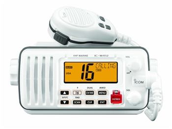
 Picture of VHF radio. Speaking via a VHF has a entire vocabulary unto itself, which I will discuss in future posts.
Captain Scott said that they could not handle these waves and that he would have to go North on the inside. The inside is actually the Intercoastal Water Way (ICW) which is very shallow in this part of Florida. Since they only draw 31/2 feet (need 5 feet of water to float) it was fine for them. But it is much to shallow for us, so Captain Steve told him that we would continue North via the Hawk Channel . The ICW and Hawk Channel intersect at Channel Five, so that is where we decided to rendezvous later that day. We most probably will have to spend the night in the anchorage near Channel Five. Which will add another day of travel to our voyage but this is one of the reasons why Captain Steve insisted that we have a weather window of 4 days of good weather. In my book today doesn't count since the weather is crappy!!!
Captain Scott said that they could not handle these waves and that he would have to go North on the inside. The inside is actually the Intercoastal Water Way (ICW) which is very shallow in this part of Florida. Since they only draw 31/2 feet (need 5 feet of water to float) it was fine for them. But it is much to shallow for us, so Captain Steve told him that we would continue North via the Hawk Channel . The ICW and Hawk Channel intersect at Channel Five, so that is where we decided to rendezvous later that day. We most probably will have to spend the night in the anchorage near Channel Five. Which will add another day of travel to our voyage but this is one of the reasons why Captain Steve insisted that we have a weather window of 4 days of good weather. In my book today doesn't count since the weather is crappy!!!

GREAT! We left the mooring field approximately an
hour ago and are already having problems!
As Bliss turned North West we turned North East,
I checked to make sure that my ‘Go to Girl’ hadn't bailed! As always she didn't let me down! She was still on board and I was very glad to
have her along!
I hoped and prayed that the weather would
improve! But I had a feeling that this wasn't the only problem that we would have to deal with on our voyage to
Bimini! Unfortunately I was
correct! It wasn't!
Sea u later!
Bahamas Bound Boat Buddies Part 6
